Sunday 29 May 2011

My story of nearly but not quite....

At last the challenge is over and sadly it wasn't possible for me to reach the last two summits, Carn Mor Dearg and Ben Nevis due to the poor weather conditions on the mountain. Nevertheless, I have walked and jogged 338 miles in training over 4 months to prepare for this challenge, in which I covered 177 miles and climbed 111 mountains, totalling an overall height of 24,366m (79,943ft). By not reaching the final two summits, I fell short by a mere 10 miles and 932m!

PBR - 34hrs 42 mins (over 4 days)
BGR - 26hrs 06 minutes (over 3 days)
CRR (minus 2 summits!) - 25hrs 37 minutes (over 3 days).
For summit splits see the RESULTS tab at the top of this blog.

I have successfully raised over £2000 for the John Muir Trust and WaterAid.
A HUGE thank you to everyone who has sponsored and supported me but especially to my parents, Ben, Jim and Arlene and to all my good friends who came to meet me on Ben Nevis!

Below is a summary of the last few days of the challenge...

LEG 3 of the CRR (Grey Corries to the Ben) - 27th May
 
Stob Coire an Laoigh
On this 'final' day it was a real struggle to leave the bothy. My morale was low and my nerves were frayed from weather watching (and worrying) for soOooo long! As I started my ascent up Stob Ban, it started to snow (SNOW!!!!). This was something I hadn't serioulsy contemplated and it worried me greatly. I called Ben and asked for him to seek out a more recent weather forecast, wanting to know if it was expected to worsen. Apparently it would be gusting 55/60mph but not worsening.

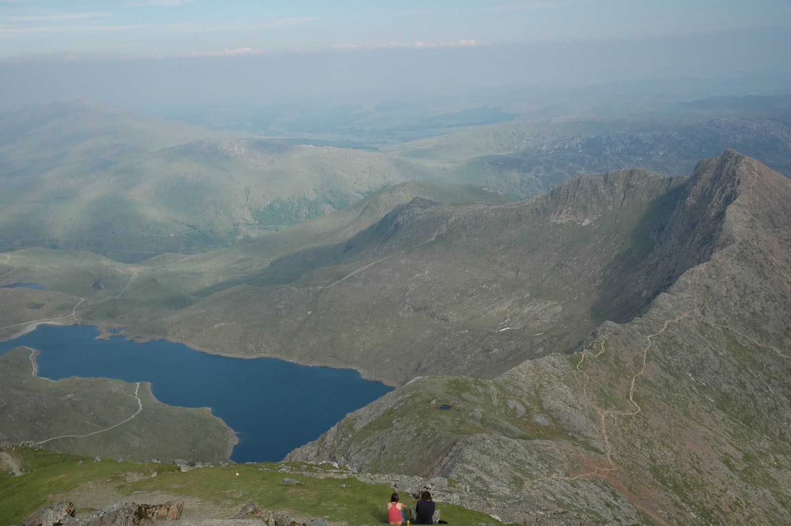
After pulling up onto the Grey Corries ridge, I was relieved that the wind was tolerable and the snow showers, (albeit it bitter) were mostly brief. Between blizzards, the views were spectacular and the sun shone through.

 In the distance, I could see the Aonachs, which were pretty white with snow and brooding under heavier weather than I was currently experiencing. The dark clouds seemed to stick there despite the strong winds.

Stob Coire Claurigh, with the snowy Anoachs in the background
Ridge of Sgurr Choinnich Mor
I enjoyed the Grey Corries and was moving quickly. As I approached Sgurr Choinnich Mor however, the weather started to darken. This mountain is quite a narrow ridge and the blizzard was relentless. For respite, I traversed the SE slope of Sgurr Choinnich Beag, which sheltered me from some of the westerly winds. At the col between Sgurr Choinnich Beag and Stob Coire Bealaich, I was horrified to see the magnitude of the cliff now facing me. I had read that there was a track/scramble directly up the ridge. During a brief clearing in the weather, I could see the crags clearly but could pick out no obvious line. Out of sheer stubborness, I scambled off up the ridge. A vague track emerged on the grass near the lip of the cliffs but it felt very much like a sheep track and the consequences of a slip were serious indeed. With the ground wet and slippy, I started to get worried that I was off course. Fortunately, I pulled over onto a flat grassy top and was not faced with yet another crag (phew!). The top-out spot was marked with a cairn, which made me think that, incredibly, this must be the/a frequented route. More than a little shaken, I pressed on over Stob Coire Bealaich.

Aonach Beag summit
At this point it started to dawn on me how HUGE the Anoachs are (1234m and 1221m). For this reason, they were much whiter and windier than anything I had yet been on. In places there were patches of neve-like snow and the grass was almost totally covered. This made for slippy going in fell-shoes and very strong winds. Progress became difficult and the winds 'toutuous' (to coin an mwis term!) I stayed well clear of the cliff on the east of the mountain, against the will of the winds and finally reached the summit. I dared not venture over to the summit cairn, which stands on the lip of the cliff and simply photographed it from a safe distance! I had never been on this mountain before, so was mightlily relieved when my bearing from the summit delivered me at the col to the N/NW rather than over any steep ground in the deeping snow.

Anoach Mor and my final summit!
The weather was now starting to feel too serious. I began to worry about finding the exact location of the descent from Aonach Mor to the watershed/col with Carn Mor Dearg. If didn't get this right, I could find myself faced with trecherous gullies and crags on Aonach Mor's west face! Even if I found it, it would be a steep and tricky descent wearing fell shoes in this snow!!  I was aware that my fell shoes no longer gave me ideal grip and that full my waterproof body cover would serve only to accelerate a slip.

As I began to ascend Aonach Mor, I was blown to my knees several times and I sometimes struggled to get back up in the wind! I used my walking poles to brace against and to give me extra grip.  I staggered onwards to the summit cairn, where I fumbled out my phone and called Ben; "I'm on Aonach Mor and i'm bailing!!!" I figured that although I felt quite energised, this was probably due only to adreanlin. Beneath this I was undoubtedly tired and would surely get cold very quickly in the event of any problem. It was definitely not sensible to push on in this weather, alone and fatigued.

Unaware that 9 friends had secretly arranged to meet me on the summit of Ben Nevis, I scampered down the ski tows of Aonach Mor with my tail between my legs.

Safely in the cafe (and rewarded with chips and hot tea) I was devastated to hear about the surprise gathering on Ben Nevis and was embarrassed to have failed so publicly (not to mention worried for those still up there!!) To console me, Jim and Arlene offered to accompany me to the summit of Carn Mor Dearg and Ben Nevis the next day and to help me complete the UK Big 3 Challenge.

So this morning, I set out AGAIN! This time in boots, with an ice axe, a rope and company. Sadly, the rain was torrential, turning to blizzards above 800m and the wind was gusting even more strongly than the day before; 75mph (and apparently 90mph on the summit of Ben Nevis). Needless to say, we repeated my earlier decision and headed down instead of walking ourselves into trouble. I could finally hear the fat lady singing.....

A video clip showing the view into Coire Leis this morning and the winds at low level.

I am obviously gutted to have failed so close to the end of the UK Big 3 Challenge but feel happy in the knowlegde that I gave it my best (safe) shot. Ultimately, I have raised over £1900 for my chosen charities and I feel confident that people's donations were well-earned. This money will make huge difference to the endeavours of WaterAid and the John Muir Trust.
The end of my attempt at the CRR!!

LEG 2 of the CRR (Loch Trieg hills) - 27th May
The weather on this day was mostly pleasant. I even had some sun!! From Stanoineag bothy, I ran along the track towards Corrour Station but striking up the SW ridge of Beinn na Lap before reaching it. High cloud meant that I could see all the surrounding hills but it also afforded my a worrying view of the snowy Anoachs in the distance...
Snowy Anoachs in the distance
Beinn na Lap summit
Despite being long, I think this is a really nice leg. Grassy and undulating compared to the other two legs. Starting to tire at this late stage in the challenge, the pull up the very steep flank of Garbh Bheinn to reach Chno Dearg was seriously draining! Stob Coire Sgriodain passed easily, so at this point (in my wisdom - ehmm) I descided to try a different decent to the dam on Loch Trieg. Dropping off the N/NW ridge of Stob Coire Sgriodain, I picked my way through crags and steep bog (not recommended) and hit the train tracks too far south. To make up time, (probably illegally..) I ran about 300m along the train tracks to reach the dam! Scooting across this, I was soon on the horribly long ascent up Stob a Coire Mheadhoin. This felt longer than ever on this day, in heavy rain and strengthening wind.
Wet but mostly still upbeat!

By the time I reached the summit, the wind strength was worrying and I had to stagger down to the col. To avoid being blown over the crags on the NE face of Stob Coire Easdain, I took a more southerly line (avoiding the ridge but also the track!) This slowed me further. I pretty much crawled into the summit shelter (which is only a few feet from the cliff face I noticed!!!) before scrabbling down the N ridge and escaping to the delights of the bothy and the company of Ben, Jim and Arlene, who were waiting to cook me up a pasta feast! (notice the wine too!!!)
Warming up...
 LEG 1 of the CRR (all 11 Mamores) - 26th May
The day started claggy and drizzly but otherwise not too bad. Visibility was terrible on the ridge and navigation turned out to be considerably trickier than 'just follow the ridge'! This is the longest and hardest single leg of the whole challenge and took me about 10.5hrs in total (from the car to the track alongside Loch Eilde Mor). It pretty much rained all day and so I got no views and my photos are awful. Thr first part of the day passed swiftly but from Am Bodach, things started to feel a real struggle. The scamble along to An Gearanach was more exposed than I was expecting and in the wet (and in trail shoes) it took more effort than I had hoped it would. On Na Gruagaichean, I had a few compass issues and from the summit accidentally traced by steps back towards the col from which I had just come (doh!) before sorting out the correct bearing. The ridge towards Binnein Mor from Na Gruagaichean is narrow and crag-lined, which took some nerve in the growing wind. By Binnein Mor i'd had enough really and was disappointed to have too far west off the north ridge during my descent down steep scree, necessitating a traverse into the col at the foot of Binnein Beag. Binnein Beag seemed to continue uphill forever, despite being relatively small compared to Binnein Mor. I was seriously starting to flag now! There is fortunately a nice runable track taking you down to the river Allt Coire an Bhinnein, after which there is a steep pull up a grass slope to the foot of Sgurr Eilde Mor.  I ascended the western ridge, which passed quickly and I was soon at the top (totally done in). It was still raining of course and in the wet, I descended to the track running alongside Loch Eilde Mor, where I met Ben. Together we walked the final 8km along the track to our bothy (Stanoineag). It was a long an depressing day!

Wet on the Mamores ridge
An Gearanach ridge
Binnein Mor summit

Coire an Lochain

Saturday 28 May 2011

Charlie Ramsay Round....still going!

A quick update: I've had (once again) some horrible weather. Nevertheless, I manged the Mamores leg on Thursday and the Loch Trieg hills leg on Friday. This round has been mostly about mental toughness (and my lack of it!!). Today I tried to finish the final leg, from Stob Ban (Grey Corries) over to Ben Nevis. Sadly, the weather was very windy again (gusting 60mph) and with quite a lot of snow falling it caused painful whipping blizzards. After several hours of very wintry weather and deepening snow on the Aonachs, I decieded to play it safe and bail off Aonach Mor (not feeling it was sensible to push things too far in such conditions while alone and fatigued!) Very disappointed to come down so close to the end but will head back tomorrow to finish off the round (although the forecast is terrible once again!!!)
Very VERY sick of bad weather now.

Wednesday 25 May 2011

Finishing the Bob Graham Round

Today i'm back in Scotland, getting ready to start the Ramsay Round.
Yesterday, I tackled both legs 3 and 4 of my Bob Graham Round. I got up at 5am and started at 6am.

Leg 3 was from Threlkeld to Dunmail Raise (14 miles and 1800m). The day started drizzly and windy (maybe gusting 50mph), which was quite a stuggle on to of Clough Head. The rolling Dodds followed:


Here the terrain was runnable and so I was able to put some miles away quickly. Gradually the showers got more wintry until I was battered with painful hail as I approached Helvellyn. Ouch!
Unimpressed!
Fortunately, the wind on Helvellyn wasn't was bad as i'd feared it might be and there was no real risk of being blown over the cliff and down Striding Edge!!

I pressed on until I was running down the steep descent off Seat Sandal and could see my parents' car in the layby. The leg took a total of 4 hours and 20 minutes, which was quicker than I had expected and bought me some valuable time.

After a change of wet clothes and some refreshment, I started the next leg at 10:50am. The cloud was above the tops now and I was hoping for a drop in the wind and rain. Actually, the sun did come out, while I was on High Raise, affording me some great views but it was still incredibly windy. The day continued in this same fashion all day, with hail showers blowing in thick white billows on the wind, alternating with bright spells.

A clear view of Pike of Stickle from Rosset Pike
Once I'd reached Bowfell, I felt I was on the home straight and this helped my motivation....

Still smiling on Ill Crag! Three summits to go...
Gradually I started to feel quite cold. By now I was wet through and could see my breath on the air it was so cold. I just couldn't warm up! So after a few photos on Scafell Pike, I decided to go round Broad Stand and on to the summit of Scafell, rather than risking the solo in the wet and while I was feeling tired.

Summit of Scafell. Last peak on my Bob Graham Round!
By the end, my joints were aching and I felt TOTALLY done-in!!! Nevertheless, I finished the final leg (16 miles and 1980m) at Wasdale at 7:00pm (having taken 8hrs 10 mins). 

Typically, the weather was lovely as I descended into the valley - beautiful.

Descending from Scafell.
In the background are the hills of Day 1 of my BGR. 


Last 2 legs of BG

Due to issues with the weather I ended up doing two legs yesterday (Total 30miles & 4000m), to finish the round.  I'm battered now but on my way back to Scotland for the last round.  Ramsay here I come!

Monday 23 May 2011

Storm force winds today

After looking through many weather forecasts and hearing much helpful advice from friends and family, I have decided NOT to venture out into the wind and rain today. So far the rain has been torrential and the winds strong, even here in town. Mountain forecasts say the winds are strengthening in the Lakes throughout the day, to a maximum of 100mph gusts and will only drop after 7pm.
My options include a night-time blitz on leg 3 (Threlkeld to Dunmail Raise) tonight or a double-leg tomorrow (30 miles), finishing in Wasdale, so as to keep on schedule....watch this space.

Here are a couple of photos/videos of my time in the Lakes so far:

Starting the BGR
(at the bottom of Yewbarrow, Wasdale).

Summit of Dale Head, after Honister Pass

                  Video of me approaching the trig point on Pillar on Day 1. Ming!

View of Blencathra from Great Calva yesterday
  
Bracing winds on the clear summit of Blencathra


Sunday 22 May 2011

Super Windy....

My day 2 of the Bob Graham round started with a 1.5h run along the road from Little Town nr Keswick to the Latrigg carpark at the bottom of Skiddaw. I started really early this morning so as to try and miss the increasing winds (gusting 60mph this afternoon). The road run was blustery and rainy, which didn't bode well for the hills to come.

The summit ridge of Skiddaw was dangerously windy really and I had to crawl into a shelter near the trig point! It felt more than 60mph up there. On the summit ridge there was little visibility, the hail was painful and the wind bitter. I only just managed to stay on my feet before dropping off the ridge towards Great Calva!

Great Calva passed easily but the river in the valley was swollen with all the recent rain and uncrossable at the usual site. After finding a better spot to wade across, I started up the huge flank of Blencathra (Saddleback). It was less windy on this summit and the cloud level was high enough to finally get a view (one of the first in the challenge so far!!!).

The scramble down the ridge immediately north of the summit cairn is exposed and so it felt pretty exciting in the gusty wind. A fantatsic looking narrow ridge dropping straight down to Threlkeld.

Feet hurting but otherwise, my body is towing the line ;0)
The hill-part of today's leg took 5h 18mins and now i'm recovering in a coffee shop!!!
The whole day was 15 miles in total.

Tomorrow's forecast is 70-80mph winds, gusting 100mph. Judging by today, this would be pretty much impossible, so here's hoping it's wrong!!!

Photos to follow at some point.

Saturday 21 May 2011

Day 1 of the Bob Graham

Had a good day today.  Did the Wasdale to Honister leg in 4hrs 50mins.  Was planning on having a cuppa with my parents at Honister slate mine but due to my faster than expect time decided to put off the cuppa until I'd done the next three hills, completed them in 2hrs. Shaved an hour off the Bob Graham round 24hr pacing!!  Chuffed to miss the rain.  Very windy though! 

Can I just say a huge thanks to the Wasdale Head inn, their hospitality was fantastic!

Friday 20 May 2011

A few pics...

A few pics of yesterday.....


Nantlle Ridge yesterday (looking towards Y Garn)

Yr Aran. Final summit on the PBR!!
Snowdon in the background.
Today i'm on my way to the Lakes..... and am VERY worried about reports of snow on the hills in Scotland. PLEEEEASE thaw!!!!

Thursday 19 May 2011

Final day of the first round

Finished the Paddy Buckley round on Yr Aran near Snowdon today  :O) The leg took 8hrs giving me a final total of 35hrs on the hill over the 4 days!! Driving to the lakes tomorrow ready for the next round.

Wednesday 18 May 2011

Day 3- The Moelwyns

Today (the Moelwyns) went well, it took 7hrs, which I was really pleased with and the weather was better which was an added bonus.  I may even get some sun tomorrow but better not speak too soon!

Tuesday 17 May 2011

Day 2 of the PBR....

Day 2 of the PBR is in the bag (albeit slowly!)
The day took 9hrs in persistent rain and clag (again). Hoping for the weather to improve.
Moel Siabod today....
Moelwyns tomorrow.....

Monday 16 May 2011

The first day!!

Day 1 complete in 9hrs. Strong winds, rain all day and clouds from about 400m and I'm 100% spent! :-O

Friday 13 May 2011

Last post before I start.....


View from Snowdon,
my first ever time on this summit!
(2006)
I leave for Wales this weekend!! I still have some packing left to do but on Monday morning (in the forecast drizzle and mist) i'll be starting up Snowdon....

If I can post updates of my progress during the challenge I will (although I can't promise any regularity!!)

Watch this space...
  

Thursday 12 May 2011

GOOD LUCK FROM JOHN MUIR TRUST

Hi Keri

With your challenge starting on Monday 16th May, I just wanted to email and wish you the best of luck for the UK BIG 3 Challenge.

I’d also like to thank you for all your fantastic fundraising to date. We really do appreciate all your hard work to promote the Trust and raise funds to help us conserve, campaign and inspire people about wild land and wild places. 

On behalf of the Trust, I wish you the best of luck for all the Rounds!

Best wishes

Maggie Briggs

Membership Officer
John Muir Trust

Monday 9 May 2011

One Week to Go!!!

UK BIG 3 CHALLENGE: 16th May 2011
 
One week to go and i've done all the training i'm going to do.....This week i'm going to rest, rest, rest and do a LOT of eating! I am happy to say that I have already reached (surpassed!) my £1000 sponsorship target for Wateraid and am over halfway to reaching the same target for the John Muir Trust.

And I am still collecting donations.....

A HUGE thank you all to those VERY generous people who have already donated and offered me advice and support.

Sunday 8 May 2011

Final Training weekend!

On Saturday I was brought back to earth with a bump after all the dry and sunny weather we've had recently, by a wet, claggy and very windy day spent running the Bridge of Orchy hills: 28km (17.5 miles) and 2731m of ascent (no camera, sorry!)

Greg and I set out from the train station at 9:30am and started up the main track to the beaclach at Coire an Dotaidh. The day started well, with only light drizzle, low winds and the promise of cloud lifting. We took a surprisingly pleasing line from the col, which traversed the western slopes of Beinn Dorain on a rocky track. This track leads round the southern end of the summit, requiring a switchback to the summit at 1076m. From here we headed in a northerly direction and then NE to Meall Garbh. We intended to descend the grassy ridge NE from here but my sloppy compass bearing drew us too far north and in the end we descended to the wee lochan at Grid Ref [332392]. The line involved chunky scree at the top and boggy, rocky terraces further down. Nevertheless, we reached river Allt Coire a' Gabhalaich in good time. At this point the rain had ceased and we had dropped into warmer, less windy climes. Therefore, we packed away waterproof layers and crossed the river to traverse the lower SE facing slopes of Beinn Achaladair. Keeping as high as possible, we later joined the old military road at the foot of Beinn a' Chuirn. This was to be our second hill of the day and involved an evil ascent up very steep grass and (at the top) rock/scree. It was a killer this early in the day and secretly we both worried what the rest of the day would feel like if it felt this difficult so early on! On reaching the top, we were surrounded by thick cloud and our bearing to the summit brought us slightly too far west. After then following the higher ground to our east, we found the true summit; a small cairn on the top of the most circular, rounded hill I have ever been on! At 923m, this mountain is not classed as a Munro (presumably due to its proximity to its taller neighbour, Beinn Mhanach at 953m).

From Beinn a' Chuirn we dropped to a broad col to the NE at 849m before ascending a good track to the top of Beinn Mhanach. I had started to get rather cold by now and had put on a hat and mitts, so we decided to seek some shelter from the strengthening wind and have a bite to eat. We stopped above the crags running NW from the summit of Beinn Mhanach. From this lunch spot our ascent route up Meall Buidhe lay directly opposite, across Gleann Cailliche. From this angle it looked impossibly steep and improbable but fortunately by the time we had dropped to the river, Allt Cailliche, this apparent angle had eased and it didn't look as bad as our first impression.

We followed the E bank of the small river running into Allt Cailliche at Grid Ref [369425], which enabled us drink regularly on the way up. In the coire we were sheltered from the wind and we decided to follow the river to the col directly, rather than veer off up Meall Buidhe. It was a good choice, because even though it seemed to go on forever, it was good ground and we popped out at the col at 932m above Lochain a' Chreachain. By this time the weather has seriously deteriorated and we stopped at the col to layer-up in the strong wind.

From here we followed a good track heading easterly over rocks to the summit of Beinn a' Chreachain (1081m). On the summit slopes, the wind was very strong and I lurched left and right with the powerful gusts. As we reached the summit it began to rain and we had to delve into our bags for our waterproofs again. We didn't stop long, as it was rather chilly and instead turned and descended back to the col again.

From here, the terrain improved dramatically and good running was had along a grassy ridge, over Meall Buidhe and down to the col at 813m. We glimpsed fleeting views out over Rannoch Moor and were impressed by the cliffs lining the coire now visible below us.

We ascended a zig-zagging path up Beinn Achaladair and were soon at the first cairn marker at 1036m. From here, we jogged along this flat-topped hill looking for our true summit at 1038m. It didn't seem to have a cairn until much further on than expected though. The weather had again taken a turn for the worse and now we were pelted with hail stones speeding along in the wind. Nevertheless, we pressed on (using a crab-like sideways gait to avoid facing into the hail!). We ran along the ridge, skirting its 1002m top and dropping, over good running ground to the final col before Beinn an Dotaidh at 768m. From Beinn Achaladair, this final mountain had looked savage, rearing up steeply and presenting a considerable undertaking this late stage in the journey! There was nothing else to do though but start the final slog uphill. Jelly babies powered us to the southern top at 993m and from here, the thought of ticking our 5th and final munro of the day drove us on to the eastern summit (which lay to the north of us) at 1004m.

A quick handshake marked our success and we quickly began our run down over soft and gradual terrain, across the coire to the south and back to the beaclach at Coire an Dotaidh, 744m. We finally returned by the same path back the car.

The whole round trip took us a respectable 8.5hrs and we were relieved to be home and dry, when the rain began to pelt even harder than it had all day. Yuk!!

A good hard run and ideal final training day. Cheers Greg!

Approaching Sron na Lairig
Sunday: Today we walked 3km up the Lairig Eilde to the foot of the classic scramble, Sron na Lairig (2/3***). Unfortunately, the rain was so heavy and persistent that we were soaked through before we arrived. At the col we decided that given the rain and high winds, we would save the scramble for a sunnier day and headed back.

Typically, the sun came out in the afternoon to reveal a glorious sunny sky....long may it continue (ideally for another month!!)

Thursday 5 May 2011

Another morning run....

Loch Creran, Argyll

I had a good 10K road run around Loch Creran this morning before work.
A shame to be running in drizzle again after such a brilliant spell of sunny weather. Fingers crossed it comes back in a week's time!! (Gulp!!)

A girl from Bude!!

The Bude and stratton Post (local newspaper of my hometown, Bude in Cornwall) have printed a news story on the UK Big 3 Challenge in this week's copy:
http://www.bude-today.co.uk/news.cfm?id=15308&searchword=keri%20page

For the full article you'll have to buy a copy!!

Tuesday 3 May 2011

Climbing holiday and long walk ins...

Since Thursday 28th April I have been on a 5 day climbing trip in the NW of Scotland. Not exactly ideal training for the challenge but a perfect use of the spell of good weather!  

 
Sea-level traversing
in Shiegra
   
Old Man of Stoer

Waves over the Tyrolean
 
Tyrolean Traverse


A long walk-in to this crag with big packs for sleeping in Carn More barn!
Our 13 mile walk-in to Carn More from Poolewe

Fionn Butress, Carn More

Gob, Carn More